Join Us in Discovering LA by Metro

Illuminated Metro System Maps are found in the Metro stations.
You do not need a car to enjoy Los Angeles!
We’ll help you avoid the stress of traffic and parking.
Riding the LA Metro light rail/subway is an easy, stress-free way to get around LA with no traffic and parking hassles. For tourists and locals alike, it is an economical way to see LA. Many popular tourist destinations and LA attractions are near Metro rail stations. And each station has its own flair with unique public art.
To start, scroll down this page or click on one of the links:
Getting To and From LAX by Metro
Metro Maps to Help You Plan Your Adventure
Use Metro Line Maps to Focus Your Travel Plans
Metro Red Line Metro Purple Line Metro Gold Line
Metro Blue Line Metro Green Line
Metro Expo Line
Getting To and From LAX by Metro
There are several options for getting to and/or from Los Angeles International Airport (LAX) via Metro. The best route depends on your location and/or destination in Los Angeles. Studying the Metro System Map below (and using Google Maps, or other mapping techniques) will help you determine your best plan.

At the Aviation/LAX Station, artist Richard Turner’s living room installation celebrates the exuberance of mid-century modern American design and the expansive optimism of the 1950s aerospace industry. Waiting for their trains, passengers are shielded from the wind by glass screens printed with quotations from Beat Generation writers.
If you are coming from or going to a destination on the Green Line or the southern end of the Blue Line, we suggest using the free shuttle to and from the Metro Green Line Aviation/LAX station. To go from LAX to the Metro Rail Green Line Station, travelers should board the LAX Shuttle “G” under the blue LAX Shuttle & Airline Connections sign above the Lower/Arrivals Level islands in front of each terminal. Going to the airport, this shuttle is on the ground level of the Metro Green Line Aviation/LAX station. Remarkably, the shuttles coordinate with the arrival of the Metro light rail trains.
If you are coming from or going to a destination off the Red/Purple or Gold Lines or the northern end of the Blue Line, the LAX FlyAway® bus (currently $8 one-way) to and from Union Station is more convenient. The FlyAway service operates from Bus Stop 9 at the Patsaouras Transit Plaza, on the east (Vignes St.) side of Union Station, and stops at every LAX terminal. Dropoffs are on the Upper/Departures Level, and pickups are from the Lower/Arrivals Level islands in front of each terminal under the green FlyAway, Buses & Long Distance Vans sign. There are also LAX FlyAway buses to and from Irvine, Hollywood, Van Nuys, and Westwood; fees vary.
Of course, there are numerous commercial shuttles and taxis as well as Lyft and Uber. All are more costly than taking the Metro, but they may be easier in some cases. Use your best judgement for what suits your needs.
Hint: Study the Metro System and Line Maps to plan your route. Our Riding Metro 101 page explains the fares and transferring between lines.
Metro Maps to Help You Plan Your Adventure
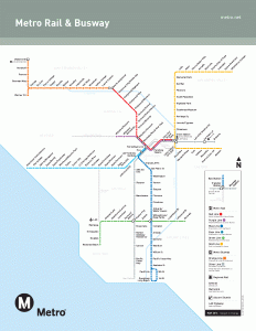
The Metro System Map shows all light rail lines plus two express bus lines.
Any journey begins with a desired destination and a known starting point — so where are you and where do you want to go? The system overview map at left will help you see the big picture, and the individual line maps below will help you focus. (Click on each map to enlarge it, then click on the full size numbers above the enlarged map to further enlarge it.)
The Metro Duo will show you LA via the Metro light rail/subway’s Red, Purple, Gold, Blue, Green, and Expo Lines. Our blog menu on the right lists many events and popular destinations, and each post has a map showing the proximity to the nearest Metro station. Riding Metro 101, our page on riding, will explain the fares.
Note: the Orange and Silver Lines are express bus lines and are not covered by this website. We also do not include information on Metrolink, useful commuter rail lines, and Amtrak, the national railroad lines.
Schedules and fares for all lines should be checked before beginning your journey.
Hint: Use Google Maps and the Metro station street locations to orient yourself. Our Riding Metro 101 page explains the fares and transferring between lines.
Use Metro Line Maps to Focus Your Travel Plans
Metro Red Line

The Red Line goes from Downtown LA Union Station to North Hollywood.
The Metro Red Line goes between North Hollywood and Union Station in Downtown LA. Many attractions of interest to tourist and locals are found along this line: Olvera Street (Union Station); Disney Concert Hall (Civic Center Station); El Capitan Theater and Hollywood & Highland Center (Hollywood and Highland Station); Pantages Theater (Hollywood and Vine Station); MacArthur Park (Westlake/MacArthur Park Station); and Universal Studios (Universal City Station).
The Red Line is a subway and is entirely underground.
Metro Red Line Station Locations (with bike and car parking information):
Union Station
(transfer to Gold Line)
801 N. Vignes St., Los Angeles 90012
Nearby Paid Parking (Independent)
Union Station – 8 Bike Rack Spaces
Gateway – 16 Bike Rack Spaces/32 Bike Lockers

Commemorating the first neon sign in the United States, which was posted around the corner from Pershing Square in 1924, neon artist Antonakos created “Neons for Pershing Square,” a series of twelve neon sculptures suspended from the station’s ceiling.
Civic Center (Disney Concert Hall)
101 S. Hill St., Los Angeles 90013
Nearby Paid Parking (Independent)
10 Bike Rack Spaces
10 Bike Lockers
Pershing Square (Central Library)
500 S. Hill St., Los Angeles 90013
Nearby Paid Parking (Independent)
4 Bike Rack Spaces
7th St/Metro Center
(transfer to Blue and Expo Lines)
660 S. Figueroa St., Los Angeles 90017
Westlake/MacArthur Park (MacArthur Park)
660 S. Alvarado St., Los Angeles 90057
18 Bike Rack Spaces
Kiss & Ride Drop-off
Wilshire/Vermont
3191 Wilshire Blvd., Los Angeles 90005
Nearby Paid Parking (Independent)
8 Bike Rack Spaces
16 Bike Lockers
Vermont/Beverly
301 N. Vermont Ave., Los Angeles 90004
14 Bike Rack Spaces
Vermont/Santa Monica
1015 N. Vermont Ave., Los Angeles 90029
18 Bike Rack Spaces
4 Bike Lockers
Vermont/Sunset
1500 N. Vermont Ave., Los Angeles 90027
10 Bike Rack Spaces
4 Bike Lockers
Hollywood/Western
5450 Hollywood Blvd., Los Angeles 90028
36 Bike Rack Spaces
2 Bike Lockers
Hollywood/Vine (Hollywood)
6250 Hollywood Blvd., Los Angeles 90038
Nearby Paid Parking (Independent)
26 Bike Rack Spaces (Future Bike Room)
Hollywood/Highland (Hollywood)
Hollywood Blvd./Highland Ave., Hollywood 90028
Nearby Paid Parking (Independent)
Universal City (Universal Studios)
Lankershim Blvd./Universal Terrace Pkwy., North Hollywood 91608
On-site Parking – 779 Spaces ($3.00/Day)
Paid Reserved On-site Parking – 125 Spaces
16 Bike Rack Spaces
30 Bike Lockers
Kiss & Ride Drop-off
North Hollywood
Lankershim Blvd./Chandler Blvd., North Hollywood 91601
On-site Parking – 803 Spaces ($3.00/Day)
Paid Reserved On-site Parking – 298 Spaces
95 Bike Rack Spaces
44 Bike Lockers
Metro Purple Line

The Metro Purple Line goes from Downtown Union Station to Mid-Wilshire area.
The Purple Line shares all but two stops with the Red Line. The Purple Line is a subway line and is entirely underground.
Metro Purple Line Station Locations — not shared with Red Line (with bike parking information):
Wilshire/Normandie
3510 Wilshire Blvd., Los Angeles 90005
Wilshire/Western
3775 Wilshire Blvd., Los Angeles 90005
8 Bike Rack Spaces
16 Bike Lockers
Metro Gold Line
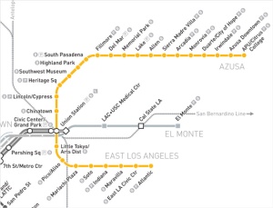
The Metro Gold Line runs between Pasadena and Azusa.
The Metro Gold Line is a multicultural adventure running between Azusa and East Los Angeles, with 27 stations having multiple attractions for tourists and locals, including Chinatown, Little Tokyo (and the Geffen Contemporary at MOCA), and Mariachi Plaza.
The Metro Gold Line is a light rail line that runs above ground except at two underground stops (Mariachi Plaza and Soto Stations) and two partially underground stops (Memorial Park and Del Mar Stations). The Gold Line tracks are elevated in the center of the 210 Freeway for part of its route in Pasadena — at the Sierra Madre Villa, Allen Ave., and Lake Ave. Stations.
Metro Gold Line Station Locations (with bike and car parking information):
APU/Citrus College
905 N Citrus Av, Azusa 91702
On-site Parking – 200 spaces ($3.00/Day)
18 Bike Rack Spaces
24 Bike Lockers
Azusa Downtown
780 N. Alameda Ave., Azusa 91702
On-site Parking – 237 Spaces ($3.00/Day)
3 EV Charging Stalls
20 Bike Rack Spaces
24 Bike Lockers
Irwindale
16017 Avenida Padilla, Irwindale 91702
On-site Parking – 350 Spaces ($3.00/Day)
3 EV Charging Stalls
14 Bike Rack Spaces
24 Bike Lockers
Duarte/City of Hope
1777 Duarte Rd., Duarte 91010
Free On-site Parking – 125 Spaces
3 EV Charging Stalls
19 Bike Rack Spaces
24 Bike Lockers
Monrovia
1651 Primrose Ave., Monrovia 91016
On-site Parking – 350 Spaces ($3.00/Day)
3 EV Charging Stalls
20 Bike Rack Spaces
24 Bike Lockers
Arcadia
201 N. First Ave., Arcadia 91006
Free On-site Parking – 300 Spaces
20 Bike Rack Spaces
24 Bike Lockers
Sierra Madre Villa
149 N. Halstead St., Pasadena 91107
On-site Parking – 950 Spaces ($3.00/Day)
Paid Reserved On-site Parking – 60 Spaces
10 Bike Rack Spaces
Allen (Pasadena City College)
395 N. Allen Ave., Pasadena 91106
28 Bike Rack Spaces

A linear field of California golden poppies spring from the spine of the East Los Angeles Civic Center station’s canopies as part of the installation “Through the Looking Glass or Traveling at the Speed of Light (Rail)” by Clement Hanami.
Lake
340 N. Lake Ave., Pasadena 91101
Reserved On-site Parking – 100 Spaces
18 Bike Rack Spaces
Memorial Park (Old Town Pasadena)
125 E. Holly St., Pasadena 91103
8 Bike Rack Spaces
16 Bike Lockers
Del Mar
230 S. Raymond Ave., Pasadena 91105
Paid Reserved On-site Parking – 290 Spaces
26 Bike Rack Spaces (Bike Room)
Fillmore
95 Fillmore St., Pasadena 91105
Free On-site Parking – 131 Spaces
Paid Reserved On-site Parking – 16 Spaces
12 Bike Rack Spaces
South Pasadena
905 Meridian Ave., South Pasadena 91030
Paid Reserved On-site Parking – 118 Spaces
14 Bike Rack Spaces
Highland Park
151 N. Avenue 57, Los Angeles 90042
8 Bike Rack Spaces
16 Bike Lockers
Southwest Museum
4600 Marmion Way, Los Angeles 90065
6 Bike Rack Spaces
Heritage Square
3545 Pasadena Ave., Los Angeles 90031
On-site Parking – 129 Spaces ($3.00/Day)
4 Bike Rack Spaces
Lincoln/Cypress
370 W. Avenue 26, Los Angeles 90031
Free On-site Parking – 89 Spaces
Paid Reserved On-site Parking – 5 Spaces
10 Bike Rack Spaces
Chinatown
901 N. Spring St., Los Angeles 90012
6 Bike Rack Spaces
Union Station
(transfer to Red/Purple Lines)
801 N. Vignes St., Los Angeles 90012
Nearby Paid Parking (Independent)
Union Station – 8 Bike Rack Spaces
Gateway – 16 Bike Rack Spaces/32 Bike Lockers
Little Tokyo/Arts District
200 N. Alameda St., Los Angeles 90012
12 Bike Rack Spaces
4 Bike Lockers
Pico/Aliso
1311 E. 1st St., Los Angeles 90033
12 Bike Rack Spaces
4 Bike Lockers
Mariachi Plaza
1831 E. 1st St., Los Angeles 90033
12 Bike Rack Spaces
8 Bike Lockers
Soto
2330 E. 1st St., Los Angeles 90033
12 Bike Rack Spaces
4 Bike Lockers
Indiana
210 S. Indiana St., Los Angeles 90063
On-site Parking – 43 Spaces ($3.00/Day)
12 Bike Rack Spaces
4 Bike Lockers
Maravilla
4520 E. 3rd St., Los Angeles 90022
12 Bike Rack Spaces
8 Bike Lockers
East LA Civic Center
4780 E. 3rd St., Los Angeles 90022
20 Bike Rack Spaces
Atlantic
5150 E. Pomona Blvd., Los Angeles 90022
On-site Parking – 413 spaces ($2.00/Day)
6 Bike Rack Spaces
8 Bike Lockers
Metro Blue Line

The Metro Blue Line runs between Downtown Los Angeles and Long Beach.
The Metro Blue Line runs between Downtown Los Angeles at the 7th/Metro Center (near 7th St. and Figueroa) and Long Beach. LA Live/Staples Center is next to this line at the Pico Station. LA Trade Tech College is at the Grand Station. Watts Towers are a short walk from the 103rd Street Station. Much of the line goes through industrial and residential areas.
The Blue Line is underground at the 7th Street/Metro Center Station only. Parts of the Blue Line are elevated, but most of the route is at street level, requiring this light rail line to stop for traffic at times.
Metro Blue Line Station Locations (with bike and car parking information):
7th St/Metro Center
(transfer to Red/Purple and Expo Lines)
660 S. Figueroa St., Los Angeles 90017
Pico (LA Live/Staples Center) (transfer to Expo Line)
1236 S. Flower St., Los Angeles 90015
Grand/LATTC (LA Trade Tech College)
331 ½ W. Washington Blvd., Los Angeles 90015
San Pedro St
767 E. Washington Blvd., Los Angeles 90021
Washington
1945 Long Beach Ave., Los Angeles 90021
Vernon
4421 Long Beach Ave., Los Angeles 90021
Slauson
5585 Randolph St., Los Angeles 90032
4 Bike Rack Spaces

At the Compton station, Eva Cockcroft’s ceramic tile murals celebrate contributions of various ethnic groups (African American, Latino, and Samoan) to the Compton area. Two triangular tiled columns emphasize family and are captioned with thoughts from Compton residents. Twelve panels above the platform benches depict Compton past and present.
Florence
7225 Graham Ave., Los Angeles 90002
On-site Parking – 103 Spaces ($3.00/Day)
Paid Reserved On-site Parking – 12 Spaces
12 Bike Rack Spaces
Firestone
8615 Graham Ave., Los Angeles 90002
8 Bike Rack Spaces
103rd St/Watts Towers
10100 Grandee Ave., Los Angeles 90002
Free On-site Parking – 62 Spaces
Willowbrook/Rosa Parks
(transfer to Green Line)
11611 Willowbrook Ave., Los Angeles 90059
Free On-site Parking – 975 Spaces
36 Bike Rack Spaces
6 Bike Lockers
Compton
275 Willowbrook Ave., Compton 90220
4 Bike Rack Spaces
Artesia (Crystal Casino)
1920½ Acacia Ave., Compton 90220
On-site Parking – 292 Spaces ($3.00/Day)
Paid Reserved On-site Parking – 76 Spaces
8 Bike Rack Spaces
Del Amo
20220 Santa Fe Ave., Los Angeles 90220
On-site Parking – 351 Spaces ($3.00/Day)
Paid Reserved On-site Parking – 15 Spaces
10 Bike Rack Spaces
7 Bike Lockers
Wardlow
3420 N. Pacific Pl., Long Beach 90802
On-site Parking – 82 Spaces ($3.00/Day)
Paid Reserved On-site Parking – 10 Spaces
8 Bike Rack Spaces
14 Bike Lockers
Willow St
2750 American Ave., Long Beach 90806
Free On-site Parking – 879 Spaces
Paid Reserved On-site Parking – 20 Spaces
16 Bike Rack Spaces
14 Bike Lockers
Pacific Coast Highway (Long Beach City College)
1798 N. Long Beach Blvd., Long Beach 90813
Anaheim St
1290 N. Long Beach Blvd., Long Beach 90813
5th Street
598 N. Long Beach Blvd., Long Beach 90802
1st Street
108 N. Long Beach Blvd., Long Beach 90802
Nearby Paid Parking (Independent)
Downtown Long Beach
(bus transfer point for attractions, including Aquarium and Queen Mary)
128 W. 1st St., Long Beach 90802
Nearby Paid Parking (Independent)
Bike Rack/Lockers
Pacific Av
498 Pacific Ave., Long Beach 90802
Nearby Paid Parking (Independent)
Metro Green Line

The Metro Green Line runs down the center of the 105 Freeway from Norwalk to Aviation/LAX.
The entire route of the Metro Green Line is elevated and runs in the center of the 105 Freeway between Norwalk and Aviation/LAX Stations, where it connects to LAX via free shuttle bus. This line goes through residential and industrial areas and is predominately a commuter line (with ample parking at most stations).
Metro Green Line Station Locations (with bike and car parking information):
Norwalk
12901 Hoxie Ave., Norwalk 90650
Free On-site Parking – 2050 Spaces
48 Bike Rack Spaces
40 Bike Lockers
Lakewood Bl
12801 Lakewood Blvd., Downey 90241
Free On-site Parking – 545 Spaces
22 Bike Rack Spaces
12 Bike Lockers

Working with local children, artist Joe Sam created “Hide-n-Seek,” a giant figural game located amid the freeway support columns at this elevated station. Throughout the two levels of the Willowbrook Station (which is the intersection of the Metro Blue and Green Lines), large, vibrantly colored metal cutout figures appear to be playfully engaged in this game.
Long Beach Bl
11508 Long Beach Blvd., Lynwood 90262
Free On-site Parking – 650 Spaces
12 Bike Rack Spaces
Willowbrook/Rosa Parks
(transfer to Blue Line)
11611 Willowbrook Ave., Los Angeles 90059
Free On-site Parking – 975 Spaces
36 Bike Rack Spaces
6 Bike Lockers
Avalon
11667 S. Avalon Blvd., Los Angeles 90067
Free On-site Parking – 158 Spaces
8 Bike Rack Spaces
Harbor Freeway
11500 S. Figueroa St., Los Angeles 90048
Free On-site Parking – 253 Spaces
12 Bike Rack Spaces
Vermont/Athens
11603 S. Vermont Ave., Los Angeles 90048
Free On-site Parking – 155 Spaces
8 Bike Rack Spaces
Crenshaw
11901 S. Crenshaw Blvd., Hawthorne 90303
Free On-site Parking – 513 Spaces
12 Bike Rack Spaces
4 Bike Lockers
Hawthorne/Lennox
11230 S. Acacia St., Inglewood 90304
Free On-site Parking – 623 Spaces
4 Bike Rack Spaces
Aviation/LAX (free shuttle to LAX)
11500 Aviation Blvd., Los Angeles 90045
Free On-site Parking – 405 Spaces
12 Bike Rack Spaces
20 Bike Lockers
Mariposa
555 N. Nash St., El Segundo 90245
4 Bike Rack Spaces
El Segundo
2226 E. El Segundo Blvd., El Segundo 90245
Free On-site Parking – 90 Spaces
4 Bike Rack Spaces
7 Bike Lockers
Douglas
700 S. Douglas St., El Segundo 90245
Free On-site Parking – 30 Spaces
6 Bike Rack Spaces
4 Bike Lockers
Redondo Beach
2406 Marine Ave./5301 Marine Ave., Redondo Beach 90278
Free On-site Parking – 403 Spaces
12 Bike Rack Spaces
6 Bike Lockers
Metro Expo Line
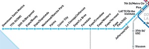
The Metro Expo Line runs between Downtown LA at 7th Street/Metro Center and Downtown Santa Monica.
The Expo Line shares two stations with the Blue Line – 7th Street/Metro Center and Pico. It opened on Saturday, April 28, 2012, with ten stations between Downtown LA at 7th Street/Metro Center and the Culver City-adjacent La Cienega/Jefferson. Two additional stations opened on June 20, 2012: the Culver City station at Venice and Robertson Blvds., which extends the line a mile further west, and the Farmdale station, which serves Dorsey High School – for a total of 12 Expo Line stations in Phase I. Phase II opened on May 20, 2016, adding 7 stations and extending the Expo Line to Santa Monica.
Metro Expo Line Station Locations (with bike and car parking information):
7th St/Metro Center (transfer to Red/Purple and Blue Lines)
660 S Figueroa St., Los Angeles 90017
Pico (LA Live/Staples Center) (transfer to Blue Line)
1236 S Flower St., Los Angeles 90015
LATTC/Ortho Institute
2460 S Flower St., Los Angeles 90007
10 Bike Rack Spaces

Metro Expo Line stations share common design elements, including undulating grids overhead.
Jefferson/USC
3214 S Flower St., Los Angeles 90007
10 Bike Rack Spaces
Expo Park/USC
661 Exposition Blvd., Los Angeles 90089
10 Bike Rack Spaces
Expo/Vermont
1043 Exposition Blvd., Los Angeles 90007
10 Bike Rack Spaces
Expo/Western
1573 Exposition Blvd., Los Angeles 90018
10 Bike Rack Spaces
Expo/Crenshaw
3428 Exposition Blvd., Los Angeles 90018
Nearby Free Parking (Independent)
10 Bike Rack Spaces
Farmdale
4420 Exposition Blvd., Los Angeles 90016
10 Bike RackSpaces
Expo/La Brea
5060 Exposition Blvd., Los Angeles 90016
20 Bike Rack Spaces
La Cienega/Jefferson
5664 W Jefferson Blvd., Los Angeles 90016
Free On-site Parking – 476 Spaces
12 Bike Rack Spaces
8 Bike Lockers
Culver City
8804 Washington Blvd., Culver City 90232
Nearby Paid Parking (Independent)
20 Bike Rack Spaces
22 Bike Lockers
Palms
10021 National Blvd., Los Angeles 90034
6 Bike Rack Spaces
8 Bike Lockers
Westwood/Rancho Park
10800 Exposition Blvd., Los Angeles 90064
6 Bike Rack Spaces
8 Bike Lockers
Expo/Sepulveda
10925 Exposition Blvd., Los Angeles 90064
On-site Parking – 260 Spaces ($3.00/day)
10 Bike Rack Spaces ($2.00/day)
16 Bike Lockers
Expo/Bundy
12201 Exposition Blvd., Los Angeles 90064
On-site Parking – 217 Spaces ($3.00/day)
10 Bike Rack Spaces
16 Bike Lockers
26th St/Bergamot
2602 Olympic Blvd., Santa Monica 90404
6 Bike Rack Spaces
8 Bike Lockers
17th St/SMC
1610 Colorado Ave., Santa Monica 90401
On-site Parking – 67 Spaces ($3.00/day)
10 Bike Rack Spaces
16 Bike Lockers
Downtown Santa Monica
402 Colorado Ave., Santa Monica 90401
Nearby Paid Parking (Independent)
10 Bike Rack Spaces

Passengers rush between trains.


Is there a bus that travels straight down Figueroa From the L A Coliseum to El Sedundo Blvd. (Los Angeles CA.). What is the fare and when do the buses stop running
Hi, Christine, and thanks for reading our blog! Apologies for the delay in response — we were out of the country and didn’t have reliable internet access.
We are independent bloggers and have no connection with Metro. We also concentrate on Metro Rail and do not have much information on Metro bus routes and schedules. Regular Metro fares are $1.75 for up to two hours of travel in the same general direction. Seniors (62+) pay $.75 during rush hours on weekdays, $.35 at other times. The Silver Line bus route has an extra charge.
Metro’s home page, https://www.metro.net/, has a trip planner on it. Fill in the start and end of your trip, and it will give you routing using Metro Rail and bus service. We suggest that you use that planner to get the answers to your other questions.
Hello, I am totally new to taking any trains in Los Angeles. I’m moving shortly very close to the Gold Line Lincoln/Cypress station and work in Culver City. How do I get to Culver City from the Gold Line Lincoln/Cypress station?
Totally confused……
Hi, KL! Thanks for reading our blog!
Getting from Lincoln/Cypress to the Culver City Expo Line station is simple, but it requires two train changes:
On the Gold Line, go two stops south (toward Atlantic) to Union Station.
Go downstairs, turn right into the concourse, then turn right again when you enter the main lobby. Pass Wetzel’s Pretzels and go down to the Red/Purple Line subway — the entrance is to the right of Starbucks. You’ll need to tap your TAP card to get through the turnstiles.
Take any train three stops to 7th/Metro Station. You can’t go in the wrong direction, as Union Station is the last stop on both the Red and Purple Lines.
Go upstairs to Platform 1 — NOT Platform 2. The Expo Line departs from Platform 1, and the Blue Line from Platform 2. Before you board, be sure to tap your card on a validator —they’re located by the top of the stairs as you approach the platform.
Take the Expo Line toward Santa Monica and get off at Culver City Station. That’s it!
Can you please tell me where to park in Santa Monica to take the Expo line to the Coliseum for the Rams game on Oct. 8? I will be coming from Ventura. Thank you.
Hi, Michelle, and thanks for reading our blog!
There is a paid parking structure at Santa Monica Place, close to the Expo Line Metro Station. The City of Santa Monica has parking structures a block or two away, on 2nd and 4th Streets, that may be less expensive.
However, the least expensive parking is in Metro’s own parking lots and structures. We suggest the structure across the street from the Expo/Sepulveda Station, located on Exposition between Sepulveda and Sawtelle, which costs $3/24 hours (maximum 72 hours, btw). It’s close to the intersection of the 405 and 10 Freeways. If you’re going south on the 405, exit at the Olympic/Pico offramp and go two blocks to Exposition, then turn left.
We’ve not seen this structure fill up before Rams games yet, but we can’t guarantee that it won’t be full when you get there.
Enjoy the game!
Pingback: Buses, trains, and water taxis in Los Angeles » Tales of Travel and Tech
Have tried so many times to get a PHYSICAL map of the Metro system. Please tell me how. I tried downloading and printing a map, then putting it on one page, but every name except LAX was so condensed it was impossible to read the names of the stations! In every major city in other countries where there is an underground or metro system, maps are readily available. Why not in LA? It seems so backward, especially as it’s not always possible to get cellphone connectedness underground.
Hi, Anna! Thanks for reading our blog!
As you discovered, the LA Metro rail and bus system covers so much area that a map such as the one you downloaded can’t fit on one 8.5×11 page and still be legible.
We’re not aware of any foldable printed maps that cover the entire LA Metro system. However. the maps available at https://www.metro.net/riding/maps/ can be downloaded into your smartphone and stored there so you can access them without being on line. If you don’t know how to do that, we suggest downloading them onto your computer and e-mailing them to yourself. You should then be able to open and read the map attachments using your phone’s e-mail app.
We’re not connected to Metro other than as riders and fans. You may wish to send an e-mail to customerRelations@metro.net and suggest that they make printed maps available.
Good luck!
I need to pick up someone about 6:30pm today at the Expo/Vermont station. Where is the best place to meet them? I will be in a car, they will be getting off the train, coming east from from the west side. Thank you!
Hi, Lisa! Sorry you didn’t get a response in time. We’re not part of Metro and don’t check for comments every day.
For the record, we looked at Google Maps satellite view and didn’t get a clear answer to your question. We hope you and your friend found each other without too much trouble.
I can’t figure out how to get from pch blue line station to downtown
Hi, Gundy, and thanks for following us!
You can get to Downtown LA by taking the Blue Line toward 7th/Metro Station. The line ends there, at 7th Street between Figueroa and Flower Streets.
If you’re heading to Downtown Long Beach, take the Blue Line in the opposite direction.
To get closer to your final destination, you may want to transfer to a subway or bus at 7th/Metro or to a bus in Long Beach. Use Metro’s Trip Planner website to help you get there: http://socaltransport.org/tm_pub_start.php.
Good luck and good traveling!
It’s stupid that the “Green Line” connects neither to LAX airport, or to MetroLink on the other end.
It’s also stupid that you are forced to “load a Tap card” and can not use cash to buy a fare as needed.
Thanks for posting, David! We have no connection with Metro other than as riders and fans, so our comments are ours and not Metro’s.
The Green Line connects to LAX by a free (with a TAP Card) shuttle bus at the Aviation station. We’ve done it and it works fine.
Connecting to Metrolink from the Green Line is possible, but it’s inconvenient — it requires two transfers (Blue Line and Red/Purple Line) to get to Union Station.
It’s easy to get a TAP Card and load a fare at the ticketing machines — see our post: . Once you have a TAP Card, it can be loaded with either single fares, cash value that is automatically debited when you tap the card on the validator at the station entrance, or single or multi-day passes.